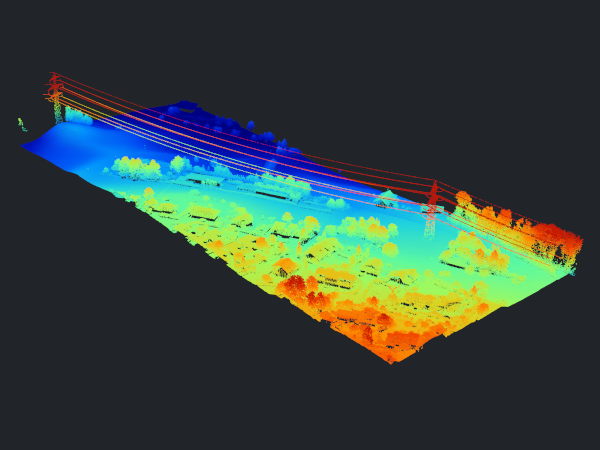
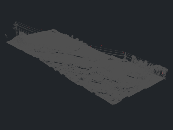
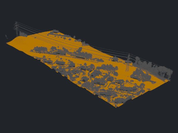
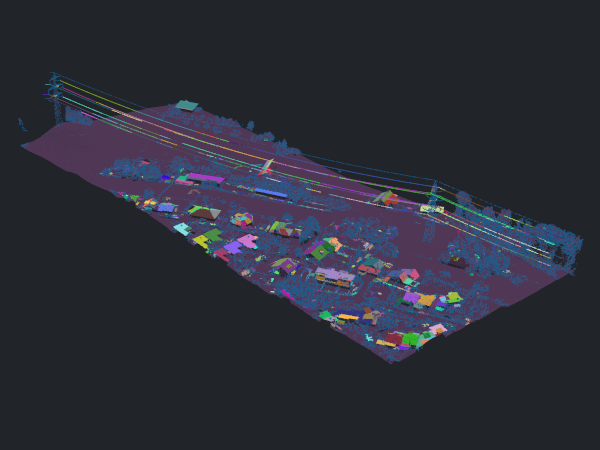
Application Example - ALS Classification

1) Manage and import data
Import your data for processing.
Python Code
import os
import project_config as cfg
from PySAGA import saga_api, lis_cmd
from PySAGA.tools import lis_filtering

# -----------------------------------------------------------------------------
# filter noise points
lis_filtering.Remove_Isolated_Points(PC_IN=pc_buff, COPY_ATTR=True, SEARCH_RADIUS=3,
                                                    MAX_POINTS=2, METHOD='label points', ATTR_NAME='noise', CLASSID=7,
                                                    CLASSID_UNDEF=1)
Python Code
import os
import project_config as cfg
from PySAGA import saga_api, lis_cmd
from PySAGA.tools import lis_classification

# -----------------------------------------------------------------------------
# ground non-ground classification
lis_classification.Ground_Classification(PC_IN=pc_buff, FIELD_CLASS='noise', COPY_ATTR=True,
                                                           INIT_CELLSIZE=50, FINAL_CELLSIZE=0.5,
                                                           FILTER_SEEDS=False, TERRAIN_ANGLE=88, MIN_EDGE_LENGTH=0.5,
                                                           MAX_ANGLE=35, MAX_DISTANCE=0.8,
                                                           Z_TOLERANCE=0.05, ATTACH_DZ=True, EXCLUDE_CLASSES='7')
4) Find planar patches
Find planar patches such as building roofs to prepare for building and vegetation classification.
Python Code
import os
import project_config as cfg
from PySAGA import saga_api, lis_cmd
from PySAGA.tools import lis_segmentation

# -----------------------------------------------------------------------------
# find planar patches
lis_segmentation.Segmentation_by_Plane_Growing(PC_IN=pc_buff, FILTER_FIELD='grdclass', COPY_ATTR=True, LOW_RANGE='0;1',
                                                                 HIGH_RANGE='3;64', METHOD_NN='radius', RADIUS_NN=1,
                                                                 MIN_K=3, ROBUST=True, ROBUST_THRES=0.1, ROBUST_PERCENTAGE=50.0,
                                                                 METHOD_ROBUST_SEARCH_POINT='search point must be included in best fit plane',
                                                                 GROWING_RADIUS=0.5, GROWING_PLANE_DIST=0.1,
                                                                 SEG_ITERATIONS=1, REGION_RADIUS=1, REGION_MINSIZE=20,
                                                                 REGION_MAXSIZE=100000, REGION_MAXANGLE=10, REGION_MAXOFFSET=0.2,
                                                                 REGION_RECALC_NORMAL=100000)
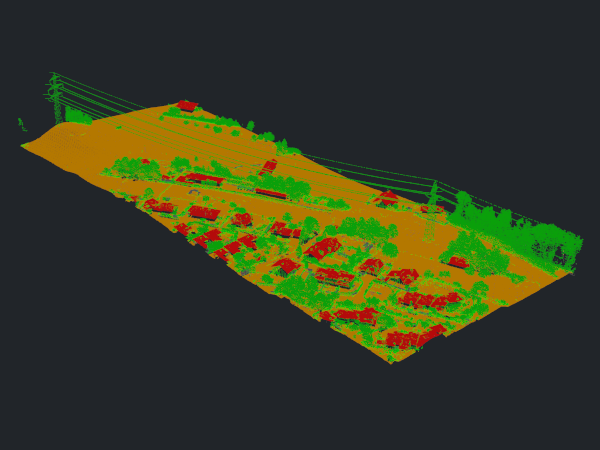
5) Classify buildings
Classify your data into ground, buildings and vegetation points.
Python Code
import os
import project_config as cfg
from PySAGA import saga_api, lis_cmd
from PySAGA.tools import lis_classification

# -----------------------------------------------------------------------------
# enhanced classification
lis_classification.Enhanced_Point_Cloud_Classification(PC_IN=pc_buff, FIELD_SEGMENTID='segmentid', FIELD_CLASSID_GROUND='grdclass',
                                                                      FIELD_DZ='dz', COPY_ATTR=True, EXCLUDE_CLASSES='7', METHOD_BUILDING='point cloud features',
                                                                      MIN_DZ_BUILDING=2.0, GROWING_RADIUS_BUILDING=1,
                                                                      FEATURE_RADIUS_BUILDING=1, MIN_NEIGHBOR_RATIO_BUILDING=60.0,
                                                                      SLOPE_ADAPTIVE_RATIO=False, MIN_POINTS_BUILDING=200, RADIUS_VEGETATION=2.0,
                                                                      MIN_POINTS_VEGETATION=5, MIN_DZ_LOW_VEGETATION=0, MIN_DZ_MEDIUM_VEGETATION=0.3,
                                                                      MIN_DZ_HIGH_VEGETATION=2, OUTPUT_CALIBRATION=False)
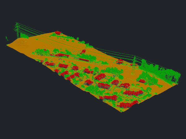
6) Clean building roofs and facades
Clean up your building classification by relabeling incorrect classifications on roofs and facades.
Python Code
import os
import project_config as cfg
from PySAGA import saga_api, lis_cmd
from PySAGA.tools import lis_classification

# -----------------------------------------------------------------------------
# clean classification
lis_classification.Clean_Building_Facades(PC_IN=pc_buff, FIELD_FILTERATTR='classid', COPY_ATTR=True, ATTR_SUFFIX='facades',
                                                            RADIUS_NN=1, BUILDING_CLASS='6;6', LOW_ATTR_RANGE='3;5',
                                                            HIGH_ATTR_RANGE='7;64', TARGET_CLASS=1)
lis_classification.Clean_Building_Roofs(PC_IN=pc_buff, FIELD_FILTERATTR='classid_facades', COPY_ATTR=True, ATTR_SUFFIX='roofs',
                                                            DIMENSION='3D search', RADIUS_NN=2.5, USE_INNER_RADIUS=False, THRES_MAJORITY=25,
                                                            TARGET_CLASS=1, FILTER_FACADE=False)

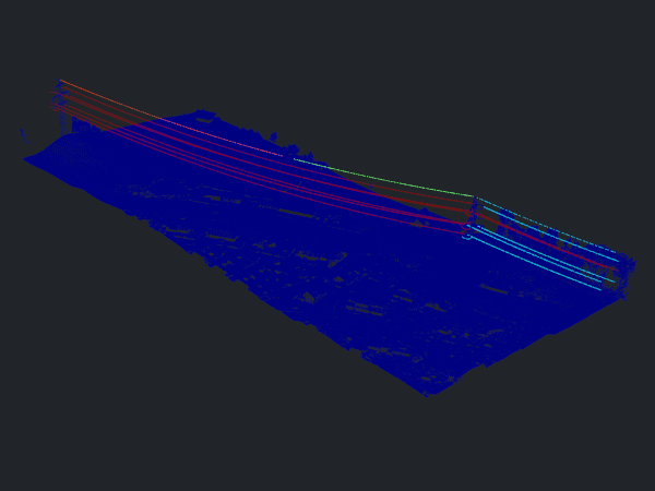
7) Classify powerlines
Classify your data into ground, buildings, vegetation and powerlines.
Python Code
import os
import project_config as cfg
from PySAGA import saga_api, lis_cmd
from PySAGA.tools import lis_classification

# -----------------------------------------------------------------------------
# powerline classification
lis_classification.Power_Line_Classification(PC_IN=pc_buff, FIELD_CLASS='classid_facades_roofs', FIELD_THRES='dz',
                                                            COPY_ATTR=True, ATTR_SUFFIX='pl', EXCLUDE_CLASSES='7', THRES_RANGE='3;1000',
                                                            SEARCH_RADIUS=5, CLASSIFY_POLES=False)
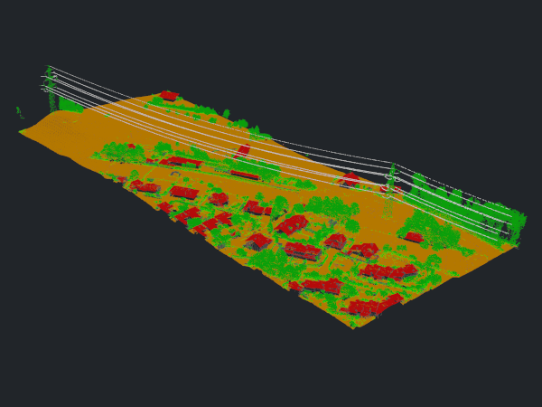
8) Minimum powerline length
Define the minimum length of the derived powerline objects for filtering.
Python Code
import os
import project_config as cfg
from PySAGA import saga_api, lis_cmd
from PySAGA.tools import lis_segmentation
from PySAGA.tools import lis_analysis

# -----------------------------------------------------------------------------
# powerline classification
lis_segmentation.Densitybased_Spatial_Clustering(PC_IN=pc_buff, FIELD_ATTR_1='X', FIELD_ATTR_2='Y', FIELD_ATTR_3='Z',
                                                FIELD_CONSTRAINT='classid_pl', COPY_ATTR=True, ATTR_SUFFIX='pl',
                                                CHOICE_DIM='3-dimensional', SEARCH_RADIUS=2, MIN_POINTS=1,
                                                RANGE_CONSTRAINT='14;14', TOL_CONSTRAINT='-0.5;0.5')

lis_analysis.Segment_Features(PC_IN=pc_buff, FIELD_SEGMENTID='cluster_pl', COPY_ATTR=True, LENGTH_2D=True)
9) Filter powerlines
Clean up the powerline classification based on the defined minimum object length.
Python Code
import os
import project_config as cfg
from PySAGA import saga_api, lis_cmd
from PySAGA.tools import lis_filtering
from PySAGA.tools import lis_arithmetic

# -----------------------------------------------------------------------------
# powerline filtering


lis_filtering.Attribute_Filter(PC_IN=pc_buff, FIELD_ATTR_1='length2d', COPY_ATTR=True, METHOD='binary flag',
                                              TYPE_1='lower limit (min)', MIN_1=5, ATTR_NAME='pl_filtered')

lis_arithmetic.Point_Cloud_Attribute_Calculator(PC_IN=pc_buff,
                                              FORMULA='ifelse(eq([classid_pl],14),ifelse(eq([pl_filtered],1),14,1),[classid_pl])',
                                              NAME='classid_pl_filtered', TYPE='1 byte unsigned integer',
                                              INCLUDE_NODATA=False)

Python Code
import os
import project_config as cfg
from PySAGA import saga_api, lis_cmd
from PySAGA.tools import lis_classification

# -----------------------------------------------------------------------------
# pylon classification
lis_classification.Pylon_Classification(PC_IN=pc_buff, FIELD_CLASS='classid_pl_filtered', FIELD_DZ='dz',
                                        COPY_ATTR=True, ATTR_SUFFIX='pylon', MIN_PYLON_HEIGHT=20,
                                        MAX_PYLON_DIAMETER=25.0, RADIUS_NN=3.0, MAX_DIFFERENCE=1.0, MIN_POINTS=200,
                                        SEED_CLASS=14, EXCLUDE_CLASSES='7', OUTPUT_CALIBRATION=False)
Complete Python Example Script
import os
import project_config as cfg
from PySAGA import saga_api, lis_cmd
from PySAGA.tools import lis_virtual
from PySAGA.tools import lis_filtering
from PySAGA.tools import lis_classification
from PySAGA.tools import lis_segmentation
from PySAGA.tools import lis_analysis
from PySAGA.tools import lis_arithmetic
from PySAGA.tools import lis_tools

SEARCH_RADIUS_OUTLIER   = 3.0
TILE_OVERLAP            = 30.0
GRD_INITIAL_CELLSIZE    = 50.0
GRD_FINAL_CELLSIZE      = 0.5
GRD_MAX_ANGLE           = 35.0
GRD_MAX_DISTANCE        = 0.8
SEARCH_RADIUS           = 1.0
SEARCH_RADIUS_PL        = 5.0
MIN_WIRE_LENGTH         = 5.0
MIN_PYLON_HEIGHT        = 20.0

@lis_cmd.proc_function_wrapper
def Task(TaskNum=0):

    # -----------------------------------------------------------------------------
    # load the shapefile with the tiling scheme used for processing
    tileshape = saga_api.SG_Get_Data_Manager().Add_Shapes('PathTileshape/Tiles.shp')

    if not tileshape.is_Valid():
        return lis_cmd.Error_Return('Loading tileshape ' + 'PathTileshape/Tiles.shp' + ' failed')

    # -----------------------------------------------------------------------------
    # get tile to process
    tile = tileshape.Get_Shape(TaskNum)

    xmin = tile.Get_Extent().Get_XMin()
    ymin = tile.Get_Extent().Get_YMin()
    xmax = tile.Get_Extent().Get_XMax()
    ymax = tile.Get_Extent().Get_YMax()

    # tiles are referenced by their lower-left corner coordinate
    lis_cmd.Message_Print('\nProcessing tile {:.0f}_{:.0f} \n'.format(xmin, ymin))

    tilename = str(int(xmin)) + '_' + str(int(ymin))


    # -----------------------------------------------------------------------------
    # start processing pipeline

    # -----------------------------------------------------------------------------
    # query point cloud (with overlap) from virtual point cloud dataset
    pc_out_list = []

    if not lis_virtual.Get_Subset_from_Virtual_LASLAZ(PC_OUT=pc_out_list, FILENAME=cfg.LASVF, COPY_ATTR=True,
                                                          CONSTRAIN_QUERY=False, FILE_COMPRESSION=True, ERROR_IF_EMPTY=True,
                                                          THIN_OUT=True, SPACING=0.01, AOI_XRANGE=str(xmin)+';'+str(xmax),
                                                          AOI_YRANGE=str(ymin)+';'+str(ymax), AOI_ADD_OVERLAP=True,
                                                          OVERLAP=TILE_OVERLAP, SKIP_EMPTY_AOIS=True,
                                                          METHOD_CLIP='lower and left boundary is inside'):
        return lis_cmd.Error_Return('Failed to execute tool on tile ' + tilename)

    if len(pc_out_list) < 1:
        return lis_cmd.Error_Return('Tile ' + tilename + ' contains no point cloud data, skipping!')

    # add the point cloud datasets to the data manager for easier memory management
    pc_buff = saga_api.SG_Get_Data_Manager().Add(pc_out_list[0]).asPointCloud()

    if pc_buff.Get_Count() < 5:
        return lis_cmd.Error_Return('Tile ' + tilename + ' has less than 5 points, skipping ...')


    # -----------------------------------------------------------------------------
    # filter noise points
    if not lis_filtering.Remove_Isolated_Points(PC_IN=pc_buff, COPY_ATTR=True, SEARCH_RADIUS=SEARCH_RADIUS_OUTLIER,
                                                       MAX_POINTS=2, METHOD='label points', ATTR_NAME='noise', CLASSID=7,
                                                       CLASSID_UNDEF=1):
        return lis_cmd.Error_Return('Failed to execute tool on tile ' + tilename)


    # -----------------------------------------------------------------------------
    # ground classification
    if not lis_classification.Ground_Classification(PC_IN=pc_buff, FIELD_CLASS='noise', COPY_ATTR=True,
                                                           INIT_CELLSIZE=GRD_INITIAL_CELLSIZE, FINAL_CELLSIZE=GRD_FINAL_CELLSIZE,
                                                           FILTER_SEEDS=False, TERRAIN_ANGLE=88, MIN_EDGE_LENGTH=GRD_FINAL_CELLSIZE,
                                                           MAX_ANGLE=GRD_MAX_ANGLE, MAX_DISTANCE=GRD_MAX_DISTANCE,
                                                           Z_TOLERANCE=0.05, ATTACH_DZ=True, EXCLUDE_CLASSES='7'):
        return lis_cmd.Error_Return('Failed to execute tool on tile ' + tilename)


    # -----------------------------------------------------------------------------
    # segmentation of planar objects for building roof detection
    if not lis_segmentation.Segmentation_by_Plane_Growing(PC_IN=pc_buff, FILTER_FIELD='grdclass', COPY_ATTR=True, LOW_RANGE='0;1',
                                                                 HIGH_RANGE='3;64', METHOD_NN='radius', RADIUS_NN=SEARCH_RADIUS,
                                                                 MIN_K=3, ROBUST=True, ROBUST_THRES=0.1, ROBUST_PERCENTAGE=50.0,
                                                                 METHOD_ROBUST_SEARCH_POINT='search point must be included in best fit plane',
                                                                 GROWING_RADIUS=SEARCH_RADIUS / 2.0, GROWING_PLANE_DIST=0.1,
                                                                 SEG_ITERATIONS=1, REGION_RADIUS=SEARCH_RADIUS, REGION_MINSIZE=20,
                                                                 REGION_MAXSIZE=100000, REGION_MAXANGLE=10, REGION_MAXOFFSET=0.2,
                                                                 REGION_RECALC_NORMAL=100000):
        return lis_cmd.Error_Return('Failed to execute tool on tile ' + tilename)


    # -----------------------------------------------------------------------------
    # building and vegetation classification
    if not lis_classification.Enhanced_Point_Cloud_Classification(PC_IN=pc_buff, FIELD_SEGMENTID='segmentid', FIELD_CLASSID_GROUND='grdclass',
                                                                      FIELD_DZ='dz', COPY_ATTR=True, EXCLUDE_CLASSES='7', METHOD_BUILDING='point cloud features',
                                                                      MIN_DZ_BUILDING=2.0, GROWING_RADIUS_BUILDING=SEARCH_RADIUS,
                                                                      FEATURE_RADIUS_BUILDING=SEARCH_RADIUS, MIN_NEIGHBOR_RATIO_BUILDING=60.0,
                                                                      SLOPE_ADAPTIVE_RATIO=False, MIN_POINTS_BUILDING=200, RADIUS_VEGETATION=SEARCH_RADIUS * 2.0,
                                                                      MIN_POINTS_VEGETATION=5, MIN_DZ_LOW_VEGETATION=0, MIN_DZ_MEDIUM_VEGETATION=0.3,
                                                                      MIN_DZ_HIGH_VEGETATION=2, OUTPUT_CALIBRATION=False):
        return lis_cmd.Error_Return('Failed to execute tool on tile ' + tilename)


    # -----------------------------------------------------------------------------
    # clean building facades
    if not lis_classification.Clean_Building_Facades(PC_IN=pc_buff, FIELD_FILTERATTR='classid', COPY_ATTR=True, ATTR_SUFFIX='facades',
                                                            RADIUS_NN=SEARCH_RADIUS, BUILDING_CLASS='6;6', LOW_ATTR_RANGE='3;5',
                                                            HIGH_ATTR_RANGE='7;64', TARGET_CLASS=1):
        return lis_cmd.Error_Return('Failed to execute tool on tile ' + tilename)


    # -----------------------------------------------------------------------------
    # clean building roofs
    if not lis_classification.Clean_Building_Roofs(PC_IN=pc_buff, FIELD_FILTERATTR='classid_facades', COPY_ATTR=True, ATTR_SUFFIX='roofs',
                                                       DIMENSION='3D search', RADIUS_NN=2.5, USE_INNER_RADIUS=False, THRES_MAJORITY=25,
                                                       TARGET_CLASS=1, FILTER_FACADE=False):
        return lis_cmd.Error_Return('Failed to execute tool on tile ' + tilename)


    # -----------------------------------------------------------------------------
    # power line classification
    if not lis_classification.Power_Line_Classification(PC_IN=pc_buff, FIELD_CLASS='classid_facades_roofs', FIELD_THRES='dz',
                                                            COPY_ATTR=True, ATTR_SUFFIX='pl', EXCLUDE_CLASSES='7', THRES_RANGE='3;1000',
                                                            SEARCH_RADIUS=SEARCH_RADIUS_PL, CLASSIFY_POLES=False):
        return lis_cmd.Error_Return('Failed to execute tool on tile ' + tilename)


    # -----------------------------------------------------------------------------
    # clustering of power line points for filtering
    if not lis_segmentation.Densitybased_Spatial_Clustering(PC_IN=pc_buff, FIELD_ATTR_1='X', FIELD_ATTR_2='Y', FIELD_ATTR_3='Z',
                                                                   FIELD_CONSTRAINT='classid_pl', COPY_ATTR=True, ATTR_SUFFIX='pl',
                                                                   CHOICE_DIM='3-dimensional', SEARCH_RADIUS=SEARCH_RADIUS * 2, MIN_POINTS=1,
                                                                   RANGE_CONSTRAINT='14;14', TOL_CONSTRAINT='-0.5;0.5'):
        return lis_cmd.Error_Return('Failed to execute tool on tile ' + tilename)


    # -----------------------------------------------------------------------------
    # calculate power line cluster lengths for filtering
    if not lis_analysis.Segment_Features(PC_IN=pc_buff, FIELD_SEGMENTID='cluster_pl', COPY_ATTR=True, LENGTH_2D=True):
        return lis_cmd.Error_Return('Failed to execute tool on tile ' + tilename)


    # -----------------------------------------------------------------------------
    # filter power line clusters by minimum length
    if not lis_filtering.Attribute_Filter(PC_IN=pc_buff, FIELD_ATTR_1='length2d', COPY_ATTR=True, METHOD='binary flag',
                                              TYPE_1='lower limit (min)', MIN_1=MIN_WIRE_LENGTH, ATTR_NAME='pl_filtered'):
        return lis_cmd.Error_Return('Failed to execute tool on tile ' + tilename)


    # -----------------------------------------------------------------------------
    # relabel power line classification
    if not lis_arithmetic.Point_Cloud_Attribute_Calculator(PC_IN=pc_buff,
                                                               FORMULA='ifelse(eq([classid_pl],14),ifelse(eq([pl_filtered],1),14,1),[classid_pl])',
                                                               NAME='classid_pl_filtered', TYPE='1 byte unsigned integer',
                                                               INCLUDE_NODATA=False):
        return lis_cmd.Error_Return('Failed to execute tool on tile ' + tilename)


    # -----------------------------------------------------------------------------
    # pylon classification
    if not lis_classification.Pylon_Classification(PC_IN=pc_buff, FIELD_CLASS='classid_pl_filtered', FIELD_DZ='dz',
                                                       COPY_ATTR=True, ATTR_SUFFIX='pylon', MIN_PYLON_HEIGHT=MIN_PYLON_HEIGHT,
                                                       MAX_PYLON_DIAMETER=25.0, RADIUS_NN=3.0, MAX_DIFFERENCE=1.0, MIN_POINTS=200,
                                                       SEED_CLASS=14, EXCLUDE_CLASSES='7', OUTPUT_CALIBRATION=False):
        return lis_cmd.Error_Return('Failed to execute tool on tile ' + tilename)


    # -----------------------------------------------------------------------------
    # remove tile overlap
    pc_out = saga_api.SG_Get_Data_Manager().Add_PointCloud()

    if not lis_tools.Clip_Point_Cloud_with_Extent(PC_IN=pc_buff, PC_OUT=pc_out,
                                                      X_EXTENT=str(xmin)+';'+str(xmax), Y_EXTENT=str(ymin)+';'+str(ymax),
                                                      METHOD_CLIP='lower and left boundary is inside'):
        return lis_cmd.Error_Return('Failed to execute tool on tile ' + tilename)


    # -----------------------------------------------------------------------------
    # save classified tile (without overlap)
    pc_out.Save('YourOutputPath' + os.sep + 'tile_' + tilename  + '.sg-pts-z')


    # -----------------------------------------------------------------------------
    # free memory resources and return success
    saga_api.SG_Get_Data_Manager().Delete()

    return True


# -----------------------------------------------------------------------------
# -----------------------------------------------------------------------------
# -----------------------------------------------------------------------------
# the main function
#

if __name__ == '__main__':

    # -----------------------------------------------------------------------------
    # start the logging

    starttime = lis_cmd.Start_Logging(False)


    # -----------------------------------------------------------------------------
    # load the shapefile with the tiling scheme used for processing

    tiles = saga_api.SG_Get_Data_Manager().Add_Shapes('PathTileshape/Tiles.shp')

    if not tiles.is_Valid():
        lis_cmd.Error_Exit('Loading tileshape ' + 'PathTileshape/Tiles.shp' + ' failed', starttime, True)

    # -----------------------------------------------------------------------------
    # process the Task function in parallel (each tile on a CPU core) with the maximum number of available CPU cores

    lis_cmd.Run_Parallel_Shapes(Task, tiles, saga_api.SG_OMP_Get_Max_Num_Threads())


    # -----------------------------------------------------------------------------
    # parallelized processing completed, now ...
    # create virtual point cloud dataset of classified tiles for subsequent processing steps (here LAS/LAZ export in script #3)
    inputfiles = lis_cmd.Create_File_List('YourOutputPath', '.sg-pts;.sg-pts-z', 'YourOutputPath' + os.sep + 'spcvf_input_file_list.txt')

    if not lis_virtual.Create_Virtual_Point_Cloud_Dataset(INPUT_FILE_LIST=inputfiles, FILENAME='YourOutputPath' + os.sep + 'tiles.spcvf',
                                                              METHOD_PATHS=1, USE_HEADER=True):
        lis_cmd.Error_Exit('Failed to execute tool', starttime, True)

    # -----------------------------------------------------------------------------
    # free memory and stop logging
    saga_api.SG_Get_Data_Manager().Delete()

    lis_cmd.Stop_Logging(starttime)